|
Come & see signs of struggle
Today’s visitors to the Oswestry Uplands greatly appreciate rolling hills and vibrant green countryside. However there have been times of real struggle in the past which have left their mark, marks which are still visible today and which visitors can explore.
|
Whose kingdom was it? |
We’re not talking of castles and forts, but of a heritage feature of recognised international significance, Offa’s Dyke.
After the Romans had left the scene, this was, for several centuries, a place of border disputes as kings and lords fought to gain control of territory. The settlements of Trefonen, Treflach and Nantmawr straddled the border of the Welsh Marches Offa was king of the Mercians and Emperor of southern Britain and ruled most of Anglo-Saxon England from AD 757 to 796. Early in his reign he was faced with attacks by the Powys Welsh along his western frontier. The success of these frequent attacks made farming and stable village life impossible. He was led to take an important decision: to defend his western boundary. A fixed defence, an enormous investment in time and effort, had to be constructed. The major earth work, the Dyke, was built to protect settlements and made much use of the steep slopes of the natural landscape. A ditch was dug on the western (Powys) side and a bank, often made of turf and soil from the ditch digging, erected on its eastern (Mercian) side. Visitors can see the Dyke north of Trefonen running into the village, and north and south of Treflach. It must be understood that the famous long-distance walk, Offa’s Dyke Path, does not always follow the course of the actual Dyke. However there is an excellent stretch where the two run together just north of Trefonen. For hundreds of years the local population lived by farming and tending livestock. The amazing pattern of footpaths and drovers’ roads are a reminder of these times. |
An age of hard labour
|
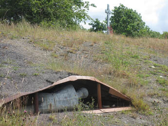
However another struggle was to leave its impact on the area. In the late1700s the discovery of coal led to much small-scale industrial and mining activity. Coal mines, mainly explored through bell pits, scattered the fields and an associated brick-making industry developed in Trefonen. As one mine was flooded and became unworkable, a new pit was opened. An amazing water course, known as The Gutter, was built to supply water. Meanwhile, in Treflach and Nantmawr quarrying of limestone for building and road making required many labourers.
The population increased hugely. In 1861 there were 1248 people living in 297 houses in Trefonen. There are far fewer people here today! The Trefonen National School opened in 1826. This was a time of considerable poverty. Workers were paid from the Efel Inn, where many then spent their money. Part of the workers’ pay was in the form of tokens which could only be spent at Tommy Shop (in Coed Y Go), so the owners of the mines had considerable control. In 1877 the Rector and Mr Dumville Lees of Woodhill started the Trefonen band as part of the promotion of temperance, and the instruments were stored in the Band Box, now the hairdressers’. On a visit to the QE II Jubilee Field you will find the spoil tip from the Old Trefonen Colliery and see interpretation panels giving more information. Six heritage walks start from here and details can be accessed through this site. Come and see what’s here. There is good provision for visitors and walkers. |